« Gmane Size Analysis Update | Home | Numeric Term IDs »
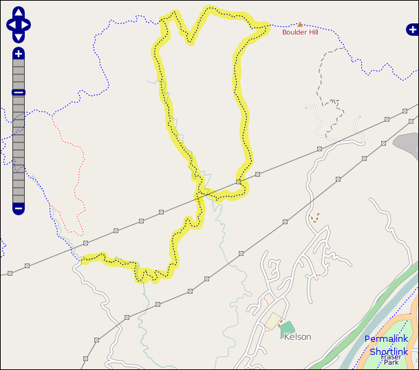
We'd meant to go for a walk on Sunday, but it got to about 3pm before we actually got moving (my fault mostly), so we decided it had better be something fairly local. It looked like it was pretty windy up on the tops, so we plumped for the Kilmister Track in Belmont Regional Park, as it looked to be fairly sheltered, was close by, and we'd not done most of the route before. Also, it wasn't in OpenStreetMap yet.
There doesn't seem to be a lot of information about this track online, so I thought it worth a quick write up. The most useful existing information we found was GWRC's brief description and map (note that the loop described there isn't the one we did).
We parked at the top of Hill Road in Belmont. The start of the track is the stile/gate on the right just beyond the map board, and is clearly signed. The track follows down Belmont Stream, with a few crossings (but we survived the day with dry feet, despite it having rained the day before). The track leaves the stream where a rough vehicle track comes in from the right and crosses the stream at a ford. You can't see the next track marker from here, but you want to follow this track to the left (across the ford).

The track now winds slowly up (and you start to get good views) and then descends into a valley where there's a signed junction. We went right, which ascends steeply to an electricity pylon, which was slightly unnerving as the cables were humming in the strong wind. The next pylon to the west is on the next ridge over, and the view of the cables sweeping down into the valley and up the other side is impressive.
The path continues to climb through herds of cows which seem to have knocked over most of the track markers, and eventually reaches a junction not far from the summit of Boulder Hill, which gives great views, particularly over Porirua Harbour.
We headed left from the junction through more cows, and eventually turned sharply right along a vehicle track with very long grass down through a block of native bush until a signed junction at a pair of gates. Here we turned left and followed the track down the valley, crossing and recrossing the stream until we reached the first junction we'd got to earlier. From there we retraced our original steps back up to the car park.
It's a pleasant walk with a variety of terrain, ranging from the enclosed valley of the Belmont Stream to the panoramic views from Boulder Hill. With a few stops for water and snacks, it took us about 3.5 hours.
Posted in tramping by Olly Betts on 2009-12-24 01:11 | Permalink